SHAMBAMAP: The Digital Land Revolution That Could Transform Property Ownership, Fight Corruption and Protect Buyers Across Africa
As Kenya struggles with land fraud, disputed ownership, encroachment and costly court battles, a Swedish-based Kenyan technology initiative is building a new model of transparency: free cadastral maps, independent professional verification, privacy protection and a proposed insurance-backed system for safer property transactions.
A New Vision for Africa's Land Sector
For generations, land has represented wealth, security, identity and opportunity across Africa. Yet in Kenya and many other African countries, the process of buying, selling, verifying and developing land remains fraught with uncertainty.
ALSO READ

Families have lost their savings after purchasing disputed properties. Banks have accepted land titles as collateral only to discover competing claims. Developers have invested millions in projects that later became entangled in litigation. Meanwhile, ordinary citizens have struggled to establish the boundaries and legal histories of properties they believed they legitimately owned.
At the centre of these challenges lies a fundamental problem: the difficulty of obtaining reliable, accessible and independently verifiable land information.
A Kenyan-founded technology platform, Shambamap.org, is seeking to change that.
Developed by James Muricho, a Kenyan entrepreneur based in Sweden, Shambamap aims to create a continent-wide digital land-information infrastructure combining geographical mapping, cadastral records, professional verification, legal due diligence and, eventually, insurance protection against specified land-transaction risks.
Its central proposition is straightforward: cadastral information should be freely accessible, while professional services can be used to verify ownership, assess property values and protect transactions.
Unlike conventional property-listing websites, Shambamap is designed to become an infrastructure platform supporting landowners, buyers, surveyors, valuers, lawyers, insurers, banks, developers and government institutions.
Free Cadastral Maps: Removing the Information Barrier
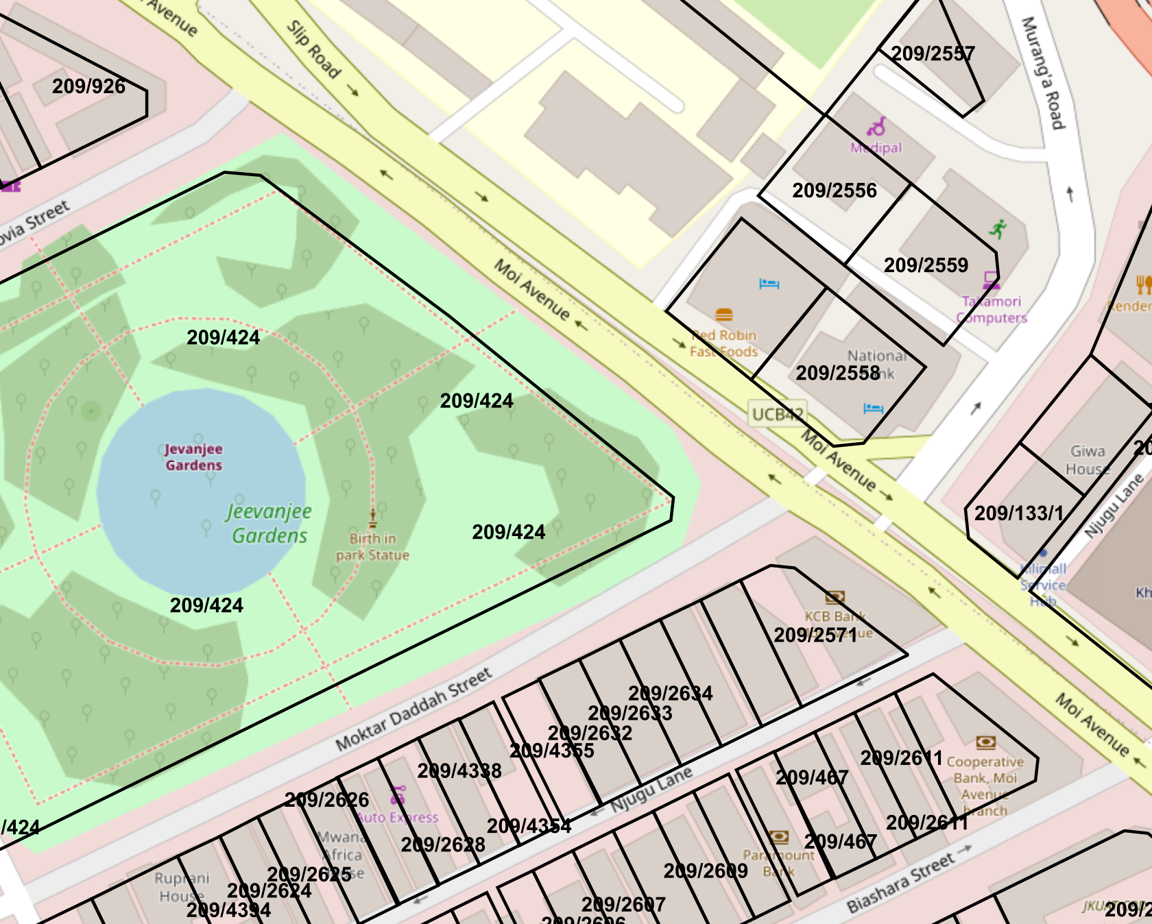
One of Shambamap's defining characteristics is its commitment to providing cadastral mapping data completely free of charge.
Cadastral maps identify individual land parcels, their geographical positions, approximate shapes and recorded boundaries. They are fundamental tools for land administration, planning, surveying and property transactions.
Historically, much of Kenya's cadastral information has been maintained in physical Registry Index Maps (RIMs), Folio Registers (FRs) and other survey documents. Accessing and interpreting these records can require considerable time, specialised knowledge and administrative procedures.
Shambamap seeks to make this geographical information accessible through an interactive digital map.
A visitor to https://shambamap.org can explore available mapped parcels, search for land using parcel references, inspect mapped boundaries and access associated historical survey sheets where available.
The platform also offers a route to locating individual parcels and sharing their map references with other people, potentially simplifying communication between landowners, buyers and professionals.
The distinction between Shambamap and Kenya's government-operated ArdhiSasa platform is important.
ArdhiSasa provides official land-administration services, including processes that may require authentication and payment of prescribed fees. Shambamap, by contrast, is committed to 100% free access to the cadastral mapping data it makes available, without charging visitors simply to view that data.
This does not mean every service offered through Shambamap will be free. Lawyers, surveyors, valuers and other professionals may charge for their expertise, while specialised transactions may involve separate service fees.
The distinction is between free access to geographical information and paid professional services.
Shambamap is also not intended to replace the official land registry. Rather, it aims to provide an additional, independently developed information and verification infrastructure that complements legally recognised government records.
A New Approach to Land Ownership Verification
Perhaps the most ambitious aspect of Shambamap is its proposed system for verifying land ownership through several independent professional disciplines.
The platform's vision is to establish what it describes as a pioneering integrated land-verification framework, bringing together surveyors, valuers and lawyers within a single digital process.
Under the proposed model, each profession would contribute a distinct form of verification.
Surveyors would examine cadastral records, geographical coordinates, boundary information and physical survey evidence. Their work would help establish whether the parcel being offered for sale corresponds to the land described in the relevant documents.
Valuers would independently assess the property's characteristics, market value and relevant physical or economic conditions. Their assessments could help buyers and lenders identify unrealistic valuations or suspicious discrepancies.
Lawyers would conduct legal due diligence, examine ownership documentation, carry out official registry searches and investigate relevant restrictions, encumbrances and disputes, tracking all records and people related to a particular parcel of land since 1963 (Kenya’s independence year), even farther back where necessary.
Together, these professionals could provide a more comprehensive assessment than any single document or professional opinion alone.
A title deed, for example, may appear authentic while the underlying land remains subject to historical irregularities, boundary disputes or competing legal claims.
By combining independent professional assessments, Shambamap hopes to make such problems easier to detect before money changes hands.
The ultimate objective is a parcel-specific due diligence record supported by identifiable professional work, rather than an unsupported declaration that a property is safe to purchase.
However, professional verification would remain subject to the applicable laws, evidence and responsibilities of the professionals involved. A Shambamap verification would not itself confer legal ownership or override a court judgment.
Insurance Protection Against Land Fraud and Corruption
Shambamap's proposed model goes beyond identifying risks. It also seeks to address the financial consequences when property transactions go wrong.
The platform envisions partnerships with insurance companies to develop policies protecting buyers and sellers against defined risks associated with land fraud, corruption, defective ownership documentation and other covered transaction failures.
Consider a buyer who purchases land after obtaining legal advice, a survey report and an official registry search, only to discover years later that an earlier transfer was fraudulent.
Even a buyer who acted in good faith may face expensive litigation and potentially catastrophic financial losses.
Shambamap proposes combining documented professional verification with insurance underwriting so that qualifying buyers and sellers could obtain additional financial protection.
The concept is not that insurance can eliminate corruption or guarantee ownership. Rather, insurance could provide a contractual financial remedy when a specified insured risk materialises.
Coverage would depend on the policy wording, exclusions, underwriting requirements, insurer licensing and applicable law.
No insurance policy should be assumed to exist merely because a parcel has been mapped or verified on Shambamap.
If implemented successfully, however, this framework could introduce a valuable new layer of confidence into African property transactions.
It could also create opportunities for Kenyan insurers to develop specialised property-title and transaction-risk products.
The Kanyotu Land Controversy: A Warning About Historical Ownership
The dangers associated with disputed land ownership are illustrated by controversies involving property associated with the late James Kanyotu, Kenya's former intelligence chief.
Land linked to the Kanyotu estate has featured in complex ownership and inheritance disputes, highlighting the difficulty of establishing uncontested rights over valuable property.
Claims surrounding a land investment involving members associated with Deliverance Church have included allegations of losses amounting to approximately KES 10 billion.
The precise amount, identities of the affected parties and legal findings concerning the alleged fraud require confirmation from court records and reliable reporting. Such allegations should not be presented as established criminal findings without that evidence.
Nevertheless, the broader problem is clear.
A property transaction can appear legitimate at the time of purchase but subsequently become entangled in disputes involving historical ownership, inheritance, alleged fraudulent transfers or conflicting documentation.
For an ordinary investor, establishing the full legal history of a parcel may be difficult, particularly where records extend back several decades.
Shambamap's proposed verification system seeks to address this vulnerability by assembling relevant historical records, survey evidence and legal assessments in one structured process.
The goal is to make it harder for problematic land histories to remain concealed until after a transaction has been completed.
Encroachment: A Growing Source of Conflict
Land encroachment is another major problem affecting Kenya's property sector.
Disputes can arise when neighbouring landowners disagree about boundaries, developers build beyond their legally recognised plots, public land is occupied without authority, or land is subdivided and sold using conflicting survey information.
Such disagreements have affected residential neighbourhoods, agricultural land, commercial developments and public infrastructure projects.
In some cases, structures are demolished after years of occupation. In others, disputes remain before the courts for extended periods, consuming substantial financial resources.
The human consequences can be severe.
Families may lose homes, developers may abandon projects, and financial institutions may find that properties securing their loans are subject to unresolved legal claims.
Shambamap aims to reduce these risks by making parcel boundaries easier to locate and compare with available cadastral records.
A person considering purchasing land could inspect the mapped parcel before engaging professionals to establish its exact legal and physical boundaries.
The platform's geographical information could also assist surveyors, lawyers, planners and government agencies in identifying potentially conflicting parcel records.
Importantly, digital cadastral maps alone cannot conclusively determine a disputed boundary. That requires authoritative survey evidence and, where necessary, official adjudication.
Nevertheless, earlier access to mapping information could help prevent some disputes from escalating into costly litigation.
Protecting Personal Information Under European Privacy Standards
Although Shambamap advocates open access to cadastral geography, it does not propose unrestricted disclosure of personal ownership information.
This distinction is central to the platform's governance philosophy.
Land parcel information can be publicly accessible without making the personal details of landowners publicly searchable.
Shambamap intends to protect personal information in accordance with applicable European Union and Swedish data-protection requirements, including the General Data Protection Regulation (GDPR).
Under the proposed approach, buyers and sellers would disclose private information to one another only voluntarily or through their authorised lawyers and other lawful professional channels.
For example, a prospective buyer could identify a parcel geographically without automatically gaining access to the owner's private telephone number, identity documents or residential address.
Where ownership verification requires confidential documents, those records would be handled through controlled professional processes.
The intention is to balance public access to land information with the rights of individuals to privacy and protection against misuse of their personal data.
Actual compliance will require appropriate technical safeguards, lawful processing arrangements, retention policies and security controls as the platform develops.
Building an Independent Source of Land Information
Shambamap's long-term ambition is to create an independently maintained digital record of land parcels across Africa.
The platform's introductory prospectus describes a model that combines information obtained through official registry searches with contributions from qualified professionals, landowners and other participants.
Historical land records would be organised alongside digital cadastral maps, allowing users to examine the development of individual parcels over time.
Such a system could help identify inconsistencies between historical survey records and more recent transactions.
It could also support the development of digital land histories that document subdivisions, changes in parcel references and relevant professional verification work.
This information would not replace legally authoritative registry records. Its value would lie in providing an additional evidence-based resource through which records can be compared and potential discrepancies identified.
Over time, such a platform could become useful to anti-corruption agencies, financial institutions, urban planners, researchers and public administrators.
Digitising Kenya's Historical Survey Records
One of Shambamap's largest undertakings is the conversion of historical cadastral sheets into usable digital geographical information.
Kenya possesses a substantial archive of paper-based survey documents, including Registry Index Maps and Folio Registers.
These documents may contain valuable information about parcel boundaries, subdivisions and historical geographical references.
However, a scanned map is not automatically a fully functional digital cadastral dataset.
The process requires georeferencing, which aligns a scanned historical map with real-world coordinates, followed by digitisation, which converts parcel boundaries into computer-readable geographical features.
The work may involve specialist geographical information systems such as QGIS, coordinate transformations, historical surveying systems and detailed quality control.
Shambamap has made an archive of georeferenced sheets available at:
https://shambamap.org/Georeferenced/
The archive represents an opportunity for surveyors, university students, geographical information specialists, software developers and other technically interested individuals to participate in the digitisation effort.
Some sheets require further work to produce accurate digital parcel boundaries suitable for integration into the platform.
Shambamap is particularly interested in volunteers who are willing to begin digitising these records without immediate financial compensation.
The project hopes that, if Shambamap becomes commercially successful, contributors may eventually be rewarded for the time and effort they invested.
However, future compensation is an aspiration, not a guaranteed payment or contractual entitlement. Any eventual reward system would need clearly defined terms, contribution records and a sustainable funding model.
For volunteers, the immediate benefits could include practical experience in geographical information systems, professional skills development and participation in an ambitious African digital infrastructure initiative.
From Land Mapping to Better Governance
Shambamap's wider significance lies in its potential contribution to public governance.
Land administration affects taxation, housing, agricultural investment, infrastructure development, environmental protection, public finance and social stability.
When reliable information is difficult to access, opportunities arise for corruption, document manipulation, speculative transactions and abuse of administrative discretion.
Accessible cadastral data could make it easier for citizens to scrutinise land-related decisions and identify discrepancies requiring official investigation.
Professional verification could introduce greater accountability into property transactions.
Documented workflows could make it easier to establish who performed a search, who assessed a boundary and what evidence supported a particular conclusion.
Insurance companies could introduce additional scrutiny by requiring defined due diligence standards before accepting transaction risks.
Together, these mechanisms could create stronger incentives for accuracy, professional responsibility and transparency.
Shambamap's governance vision is therefore broader than property sales. It is about improving the reliability of the information on which land-related decisions depend.
Opportunities for Banks, Investors and African Technology Developers
A more reliable land-information ecosystem could benefit financial institutions as well as individual buyers.
Banks frequently rely on land and buildings as security for loans. Problems involving ownership, valuation or legal restrictions can undermine the quality of that collateral.
A system combining geographical records, professional verification and documented due diligence could support more informed lending decisions.
Shambamap also envisages application programming interfaces through which developers and institutions could integrate land-related information into their own systems.
Potential applications include mortgage assessment, insurance underwriting, property valuation, infrastructure planning, urban development and investment analysis.
The platform's longer-term plans include artificial intelligence and decision-support systems capable of helping users understand whether a particular parcel may be suitable for a proposed development, subject to local planning laws and other requirements.
Its continental ambition could eventually support cross-border property investment and provide useful information to Africans living abroad.
Such expansion would require substantial investment, reliable local partnerships and careful adaptation to the different land laws and cadastral systems operating across Africa.
An Invitation to Participate
Shambamap's success will depend not only on technology but also on the participation of professionals, institutions and ordinary citizens.
Surveyors can contribute technical expertise and digitised cadastral records. Lawyers can support lawful ownership verification and historical due diligence. Valuers can provide independent assessments. Insurance companies can investigate suitable transaction-protection products.
Universities and technology incubators can help train a new generation of specialists in cadastral digitisation and land-information systems.
Landowners and prospective buyers can explore the platform, learn how its mapping tools work and contribute to the development of a more transparent property market.
Instructions and introductory information are available through the platform's guide:
The main cadastral mapping platform is accessible at:
And the georeferenced survey-sheet archive is available at:
https://shambamap.org/Georeferenced/
A Future in Which Land Information Is Accessible to Everyone
For decades, land-related uncertainty has imposed substantial costs on Kenyan families, investors, financial institutions and public authorities.
Shambamap proposes a different future: one in which cadastral maps are freely accessible, professional verification is coordinated, personal information remains protected, and insurance may provide additional protection against defined transaction risks.
The project still faces significant challenges, including the digitisation of historical records, funding, professional participation, regulatory compliance and the development of viable insurance partnerships.
Its proposed verification and insurance services must ultimately be judged by their implementation, independence and effectiveness.
Nevertheless, its underlying idea addresses a genuine public need.
Land information should not be a privilege reserved for those who can afford to navigate complex systems. It should be a foundation for transparency, lawful investment, accountable governance and economic opportunity.
If Shambamap can translate that principle into a reliable continental infrastructure, its contribution could extend far beyond digital maps.
It could help change how Africa understands, verifies, protects and manages one of its most valuable resources: land.